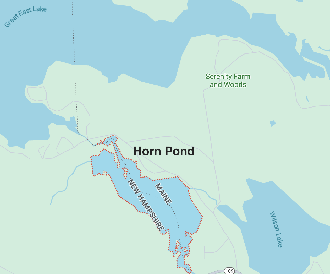
Overview of Horn Pond
Horn Pond is a small lake, considered a pond due to its relatively small size when compared to its neighbor lakes (Wilson and Great East), that lays on the border of Wakefield, NH, and Acton, Maine. The lake is spring fed and fed by the Salmon Falls River which flows from its headwaters at Great East Lake, through the Newichawannock Canal and into Horn Pond. The Lake then flows Northwest to Southeast to the Horn Pond Dam, which is used to alter lake water levels according to weather patterns. The lake then flows into the Salmon Falls River, which is 37.5 miles long. The Salmon Falls River is a tributary of the Piscataque River, which ultimately flows into the gulf of Maine. Horn Pond has 5.84 miles of shoreline, 51% of which is small camps and 44% of which is undeveloped.

Acton, ME

Wakefield, NH
Acton & Wakefield
Acton, which is in York County, Maine, was settled by American colonists in 1776. The land on which Acton lays was originally owned by the Newichawannock tribe until 1661 when it was ceded to the British settlers. Acton is a very small town with a population of 2,671.
Wakefield, which is in Carroll County, New Hampshire, was originally settled in 1749 by a group from Dover, NH. Wakefield is also a small town, with a total population of 5,201.
Together, these two towns form the governing bodies that oversee Horn Pond.
History of the Lake
Unlike its neighbor lakes of Great East Lake and Wilson Lake, very little of Horn Pond’s history has been recorded. Like these two neighboring lakes, the area on and around the Horn Pond shoreline was left largely untouched from the founding of the two towns bordering the lake until about the 1820s. Prior to the 1820s, the land in this area was mostly forests with a few small settlements and towns. However, in 1822, industrialists flocked to the Salmon Falls River to build textile mills. They began to create dams and canals upstream to generate power for mills further down the river. Around this time, construction projects began on the lake to increase water flow to mills downstream. Also around this period, the Horn Family settled the lake for residential use. It is from this family that the lake gets its namesake.


Newichawannock Canal
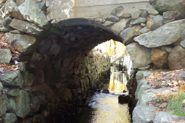
The Newichawannock Canal is a roughly three quarters of a mile long, 13 feet wide, and up to 16 feet deep canal that flows from the very most Southeastern point of Great East Lake into the very most Northwestern point of Horn Pond. It lays squarely on the border between New Hampshire and Maine. This canal, which was built by hand by farmers and the townspeople of Acton and Wakefield, was constructed from 1851 to 1868. The canal’s primary purpose was to increase water flow at textile mills further down the Salmon Falls River. It was chartered by the Great Falls mill company and designed by a local tavern owner. The Newichawannock Canal even includes a hand-made bridge, which allows travelers to cross state lines upon crossing. Similar to this canal, a dam was constructed at the most Southeastern point of Horn Pond to continue water flow.
To learn more about the Newichawannock Canal, visit https://www.nhmagazine.com/a-history-lesson-on-the-newichawannock-canal/
Or watch this video
https://www.wmur.com/article/fritz-wetherbee-newichawannock-canal-bridge/22715121.